
While I don’t have the actual calendar, there are some images of it in the Spencer County Library in Rockport (a gift of Louise Miller, 2007). The title of the calendar is “HUFFMAN’S MILL DAM”, with the following description:
“This Calendar is a reproduction of a picture of a Mill Dam constructed in the year 1816 by George Huffman, a pioneer of Spencer County, Indiana. He was one of a family group of brothers and sisters who left Lancaster County, Pennsylvania, in the year 1804 seeking territory wherein to build homes.
“On the trail from Corydon the Vincennes this family group camped at a ford on the Anderson Creek. Later George Huffman, being impressed with the country round about, returned to the place to build his home and in the year 1809 he received a title to a part of this homestead.
“During the year 1812, due to the hostilities of the Indians in the war of that year, he and his wife were required to leave this home and go to settlements in Kentucky. He joined the army as a volunteer and served as a soldier in that war. Following the war he returned with his wife and infant son , John Harrison Huffman, who was born in Kentucky in 1812, and made this his permanent residence. In time he acquired a homestead of more than 1200 acres o land.
“The Huffman family were millwrights and in the year 1816 George Huffman constructed a dam just above the ford and built the original water mill for grinding corn and sawing lumber. The settlers in the country came to the original mill for many miles to get their grist of corn and wheat ground and for lumber to construct their homes.
“George Huffman died in the year 1854 and the son, John Harrison Huffman, being the only child, succeeded to his father’s estate and continued the pursuits of his father in milling, farming and stock raising until he accumulated a competency second to none in the county. He was married in the year 1840 to Delilah L. Stapleton, a native of Kentucky, and to them were born nine children, six of whom lived to their maturity. George W., the eldest, enlisted in the 49th Ind. Vol. and was killed at the siege of Vicksburg in 1863.
“Prior to the Civil War John Harrison Huffman constructed a steam mill a short distance wet of the water mill. This mill was burned in 1864 and he then reconstructed the dam and water mill which he and he son, L. Q. Huffman, operated until the year 1888, at which time the mill was taken over by his son John R. Huffman, and was operated by him until the year 1912, when it was sold and removed and the dam was destroyed.
“This calendar is presented to you with the compliments of Benj. F. Huffman, son of L. Q. Huffman, and the great grandson of the pioneer, George Huffman.”
A calendar for 1940 has the same image of the mill dam (cropped) with the following notation:
"A steel gravaure reproduction from a photograph as it appeared some forty years ago.
"The dam and the water-powered sawmill was build by John Huffman, a Hoosier pioneer in 1820 on Anderson Creek, at a point where it serves as a boundry<sic> for Spencer and Perry Counties, Indiana, also located on the old Vincennes-Corydon Trail connecting the old territorial capitol of the Northwest Territory and Indiana's first state capitol (respectively)."
By playing with the controls in Google Earth it is possible to actually see from where the mill dam photograph was taken. One of the options in Google Earth is to overlay the aerial photographs onto a "topography" of the view. The following shows a possible position:

Looking straight down gives a better idea of where we are with respect to the bridge and houses:

The main reason for this exercise is not actually "locate" the mill site (it is still easily visible), but to better understand where it lies with respect to the town. It is obvious from the above overview image that the "heart" of Huffman was the triangle made up of the river and the two roads (which are more or less in the same place now as they were in the 1800's).
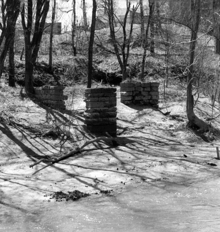
Another hint as to the position of the mill is given in the following three images. The first is a photo taken of the mill from the opposite side of the Anderson Creek just downstream from the dam. When you look at the Google Earth images, you can see that there is a natural bend at that point where one could stand to take a photo. It is not surprising then that photos of the remains of the foundation can be best viewed from the same position, as shown in the second image below.


What is of interest is the fact that the many of the various buildings in the background are still in existence or can be seen in other photographs, allowing one to better understand the size and position of the mill. One of my goals this spring is to try and get a "new" photo from the same spot and see what is left now.
A calendar for 1940 has the same image of the mill dam (cropped) with the following notation:
"A steel gravaure reproduction from a photograph as it appeared some forty years ago.
"The dam and the water-powered sawmill was build by John Huffman, a Hoosier pioneer in 1820 on Anderson Creek, at a point where it serves as a boundry<sic> for Spencer and Perry Counties, Indiana, also located on the old Vincennes-Corydon Trail connecting the old territorial capitol of the Northwest Territory and Indiana's first state capitol (respectively)."
By playing with the controls in Google Earth it is possible to actually see from where the mill dam photograph was taken. One of the options in Google Earth is to overlay the aerial photographs onto a "topography" of the view. The following shows a possible position:

Looking straight down gives a better idea of where we are with respect to the bridge and houses:

The main reason for this exercise is not actually "locate" the mill site (it is still easily visible), but to better understand where it lies with respect to the town. It is obvious from the above overview image that the "heart" of Huffman was the triangle made up of the river and the two roads (which are more or less in the same place now as they were in the 1800's).
Another hint as to the position of the mill is given in the following three images. The first is a photo taken of the mill from the opposite side of the Anderson Creek just downstream from the dam. When you look at the Google Earth images, you can see that there is a natural bend at that point where one could stand to take a photo. It is not surprising then that photos of the remains of the foundation can be best viewed from the same position, as shown in the second image below.

Finally, with a bit of Photoshop manipulation, one can overlay the foundation columns in the two images and get the following composite photo.

What is of interest is the fact that the many of the various buildings in the background are still in existence or can be seen in other photographs, allowing one to better understand the size and position of the mill. One of my goals this spring is to try and get a "new" photo from the same spot and see what is left now.
No comments:
Post a Comment